Items under Main menu > Web Maps provide functionality to load in backdrop maps (note, saving of images to BCF/JPG/TIFF might be limited due to licensing constraints from the service providers):
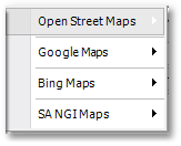
•The Open Street Maps menu provides access to the following sub-menu (note a valid licence of Swift/Edisan/Wadiso/Sewsan/HydroSWMM is required, a demo/evaluation version is not sufficient):
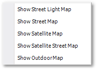
oShow Street Light Map: Places a map on screen with roads and light background (i.e. greyed-out).
oShow Street Map: Places a map on screen with roads and normal background colours.
oShow Satellite Map: Showing satellite imagery via Mapbox sourced from mostly DigitalGlobe.
oShow Satellite Street Map: Hybrid map showing satellite imagery and roads.
oShow Outdoor Map: Shows roads and contours.
•The Google Maps menu provides access to the following sub-menu (also note, currently a licence of Google Maps and Google StreetView is not provided with the evaluation/free edition of Swift/Edisan/Wadiso/Sewsan/HydroSWMM):
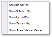
oShow Road Map: Places a Google Road Map backdrop on the screen with town info such as street/road lines and street names.
oShow Satellite Map: Displays a satellite image backdrop on the screen.
oShow Hybrid Map: Combination of Road Map and Satellite Map.
oShow Terrain Map: Displays a topographic map with contour lines as backdrop.
oShow Street View at Center: Shows a Google Street View photo at the centre location of the current screen view.
•The Bing Maps menu options are discussed in detail in the Albion 6 help (Albion 6 CAD User Guide > Main Menu > Maps). Note a valid licence from Microsoft is required.
•SA NGI Maps (from the Chief Directorate: National Geo-spatial Information and only covering South Africa) is also provided.